
Introduction
Physical Features Of India- India is a developed and vast country, consisting of a wide range of physical features related to the subject, like history, traditions, cultures, and economic development. The Himalayas are the greatest feature, which is filled with snowfall and covered with ice, making it very dangerous. It can be said as an unstable zone in which not able to move and is uncomfortable. The northern plains, rivers, and plateau are the major divisions that were present in the country of India. Also, the valleys and rivers play a one of prominent role in physical features. The country was very beautiful, filled with some of the most beautiful places, like the Andaman and Nicobar Islands.
Major physiological divisions
The characteristics of India can be categorized in the following ways;
- The himalyan mountains
- northern plains
- pensular plateau
- India desert
- costal plains
- islands
The himalyan mountains
The Himalayan Mountains stretch over the northern borders of India. The ranges of the Himalayan mountains can be demonstrated in directions from west to east direction like from the places of the Indus to the Brahmaputra. From world worldwide range, the Himalayas are one of the largest peaks, which are taller takes apart in India. The Himalayan Mountains contain the variations and parallel ranges that extend longitudinally. Valleys can be observed between the ranges of these Himalayan mountains. The inner Himalayas which it was also known as the Himadri, consist of a wide range on the direction of northern side.
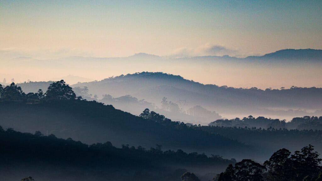
The Himalayan ranges consist the some of the tallest mountains. They are like Gurla mandhanta, Namcha Barwa, Kamet, Nanda Devi, Annapurna, manga parbat, Dhaulagiri, Makalu, Kanchenjunga, mt. Everest. The Shiwaliks extend over the area consisting of a width that varies between 900 and 1100 metres. These are ranges that are unconsolidated and sediments that are transported between the rivers. These valleys lie along with the duns like Dehradun.
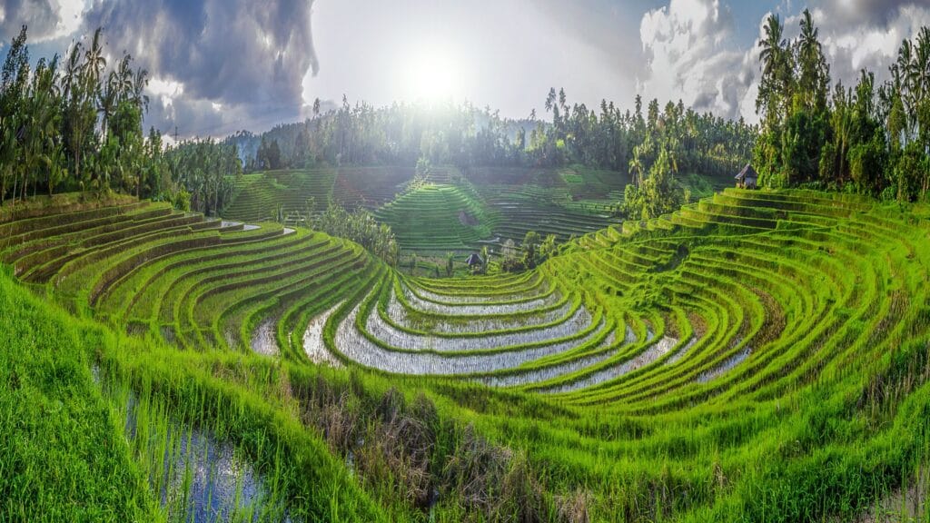
Northern plains
These plains are formed due to the presence of the three key river systems. The rivers like Ganga, Indus, and Brahmaputra combine and mix together with each other and their tributaries. The alluvial soil is the major type in which the plains are filled. The plain extended over a considerable distance of 2400 km in length and measured between 240 to 320 km in width.. These plains are full of sufficient soil with sufficient water.
The crop can be cultivated, and the farmer gets a sufficient yield according to the field strength. Rivers are a major part in getting sufficient water, which they get from rivers like the Ganga, Indus, and Brahmaputra. The plains are described as flat and uniform with no variations or relief. The unacceptable words, the expansive plains, also exhibit characteristics similar to relief. The northern plains are primarily composed of older alluvium. It was also known as bhangar, and the soil in this land was the Mizo Hills.
Peninsular plateau
The plateau is filled with large rocks and old crystalline and metamorphic rocks. Apart from the side of the Gondwana, these heavy rocks were formed by the process of breaking and drifting. The divisions of the peninsular plateau include the central highlands and the Deccan Plateau. These are located near the river of the Narmada, which is located major area of the Malwa plateau called as central highlands.
These islands are present in the direction west of and close to the direction of east. Bundelkhand is a place present in the extension of the eastern part. Near these places, plateaus like Chotapur and the Deccan Plateau are present. The Chotapur plateau is located in the direction of the east, and there itself, the Damodar River is present. The Deccan Plateau is present on the southern side where the Narmada River was present.
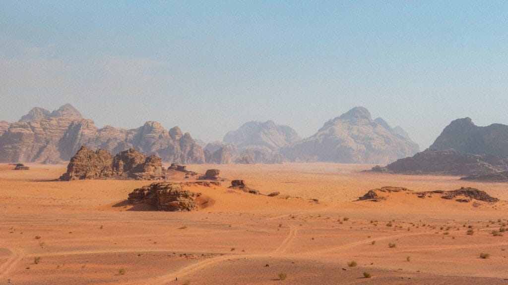
Indian desert
It was located in the area of the Aravali hills, which was on the western side. The desert completely filled with sand particles. The temperature is very high, and the rainfall count was very less in the numbers. The climate conditions are arid, and the type of vegetation is very low. During the times of the rainy the appearance of streams takes place. As soon as they disappear into the sand. where the sand intakes are completely blocked due to the absence of sufficient water. Luni River, which is very large in terms of quantity.
Survival was very difficult to live for long periods of time. No special arrangements for the people who live nearer to the areas. It was a task for the people to move forward due to unknown and unfavorable conditions. The changes in these areas occur within a shorter amount of time.
Costal plains
As per above the the information related to the plains, the peninsular plateau is flanked by prolonged coastal strips. These coastal plains are located in the Bay of Bengal on the eastern side and the Arabian Sea on the western side. The plain can be estimated on the western coast like sandwichecin the areas of Western Ghats and the Arabian Sea. Kokan is the coast present on the northern side, and the Malabar Coast is present on the southern side. These plains are wider and width as richer near the Bay of Bengal. On the northern side, it commonly known northern circuit present, whereas the Coromandel coast is in the southern part.
The Mahanadi river is present, which is very large, and also the rivers like Krishna Godavari and the river Kavri take part. In the area of the eastern coast, there is a lake named Chilika along with the rivers. In the state of Odisha, the Chilika Lake is present, which is filled with saltwater. It is situated in the river of the Mahanadi River. Agriculture is high in amount where the amount of water facilities is high. Due to proper land and soil, along with water quantity, many of the crops are cultivated. The yield gets very high in amounts within a short period.
Islands
We know that India consists of proper and free land area . Lakshadweep Islands are one of the features in India, which presents in wide range. In early times, these islands were called by another name in which later its name changed. There was also a Kavaretti island, which is the admiral and head of these islands. The plants and animals are present with greater diversity in the island area. The climatic conditions were very special to survive, many of the people try to visit this area once upon alife.
These island conditions were mostly cool, in which the water quantity was huge amounts. There was also the island containing the sanctuary of birds. The Bay of Bengal was the place of islands which extended from the northern side of north to the southern side. The area is bigger in size and in visible conditions as far full of water.
Conclusion
At the end of this article, you get sufficient information related to the physical features of India topic.it was very clear and interesting that India consists of many features. We known some of them as usual in which some are features not able to visit directly. In the presence of these physical features the country gets profit and builted as developed management. Physical Features Of India-This article gives an outline of information about physical features and activities, and the length occupied over the area. Many unknown places present such as these areas conditions a very dangerous to people and their survival. For more information about this topic, you need to refer to the quality books where every doubt can be clarified.